В настоящей статье поднимается тема, давно волнующая экспертное сообщество, а именно: насколько реально сделать Каспийское море морем не только по названию, но и по существу путем создания надежной связи его с Мировым океаном. Автор исследует одну из существующих связей – канал Волга-Дон, а также упоминает о Волго-Балтийской системе. Конечно, этих связей недостаточно для обеспечения международной торговли. Однако современные проекты строительства новых каналов делают создание такой связи вполне реальной целью, – к такому выводу приходит автор в результате проведенного исследования.
The Caspian region is landlocked although the water basin is called a sea. However, there is no outflow from the so-called “sea” to any other external body of water. The region is cut off from maritime trade, which means that the littoral countries of the Caspian are exposed to problems typical of landlocked countries. To overcome this condition there have been massive investments to build sufficient infrastructure and land-based logistics corridors. Here I will discuss another way of overcoming this issue by focusing on the canals linking the Caspian with open seas. Presently the Volga–Don Canal and Volga–Baltic waterway systems play this role but their insufficiency and limitations are the reasons that we call the region landlocked.
Global trade activities cannot be imagined without the shipping industry. Seaborne trade accounts for 90% of global trade and billions of people have benefited from the massive productivity improvements achieved by bulk, specialized, and container shipping, especially in the last 60 years (UNCTAD 2019). There is no country in the world that is entirely self-sufficient and has no need of trade with others. Every country depends on maritime trade to sell what it has a surplus of and buy what it needs because of its high efficiency and low cost. That makes the shipping industry the backbone of global trade and the engine of development for coastal countries. Figure 1 illustrates the close association between the world gross domestic product (GDP), world merchandise trade and seaborne shipments. The figure reflects that the shipping industry is one of the fundamentals of global trade since 9 out of 10 products are carried by ships.
Figure 1
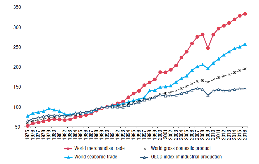
Source: UNCTAD, review of maritime transport, 2017
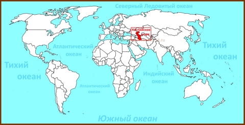
So, what happens if a country is remote from coastal regions? Around 480 million people live in 44 countries, 32 of which are on the list of the landlocked developing countries. They are geographically isolated from global markets not only because they have very few commodities to export, but also because they have no direct territorial access to the sea. Although the Caspian is labeled a “sea” and contains brackish water, this “sea” has no outflow to an external body of water, which has put the three littoral countries of the Caspian (Azerbaijan, Kazakhstan and Turkmenistan) on the above-mentioned list. Transportation and other related costs of doing business globally are crucial determinants of a country’s ability to participate in the world economy. Remoteness and weak accessibility by other transport and communications infrastructures isolate countries, hindering them from becoming part of global production networks. (Limao and Venables 2001). In short, landlocked countries are exposed to marginalization from the main global trade activities as they are dependent for transit on their coastal neighbors who may or may not have a well-developed infrastructure.
To overcome these problems, the countries of the Caspian region have massively invested in land-based logistics corridors (Mukhtarov 2020). However, this is not the only possible solution. There are existing canals, such as Volga-Don Canal and Volga-Baltic waterway system that connect the Caspian to the open seas but they have limited capacities, hence, the region is still landlocked. Due to the limited scope of this research, only the Volga–Don Canal will be discussed.[1] The littoral countries are very eager to eliminate the remoteness of the region by enhancing the available canals or creating new ones when economically feasible. The following sections discuss the present condition of the Volga-Don Canal as well as two planned canals that are intended to link the Caspian with the world ocean.
The Volga-Don Canal and Its Limitations
The Lenin Volga–Don Shipping Canal, hereafter VDSC, is part of the Unified Deep-Water System of waterways which connects five seas—the Baltic Sea, the Black Sea, the White Sea, the Sea of Azov, and the Caspian Sea (Rom 1961). It is a 101-km manmade linkage between the Volga and the Don which was constructed under Stalin reaching completion in 1952. The Volga is Europe’s longest river at about 3,700 km and accounts for two-thirds of all the river-borne freight transportation in Russia (Shaporenko et al 2019). However, since it starts in the Ural Mountains and ends in the Caspian, it did not have a link to the open seas until it was connected with the Don by the VDSC. Setting off from the Caspian, ships need to be lifted 88 meters above the Caspian and then dropped 44 meters to the Don due to altitude discrepancy along the waterway, which has been accomplished with 13 locks. Three reservoirs—Karpovka, Bereslavka, and Varvarovka—were created to balance the water level within the canal. Figure 2 illustrates the general geography of the canal.
Figure 2
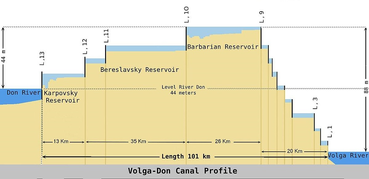
The present depth of the canal is 3.20 meters which only allows small vessels to navigate the waterway. Moreover, since it runs through a cold region, commercial usage of the canal is interrupted by the end of October and opens in mid-March or in the beginning of April. These are not the only limitations of the VDSC. From the very beginning in 1936, Stalin imposed an act that prevents all foreign vessels from using inland Soviet waterways (Article 5 of the Russian Inland Waterways Act). By 1994, slight changes had been made to the rules, allowing foreign-flagged vessels to navigate through the canal only with the permission of the Russian government. The tariffs for the usage of the VDSC are discriminative.
While Russian shipowners pay around 5,000-6,000 USD for passage, Azerbaijani owners, for example, must pay five times that amount, i.e. 20,000-25,000 USD, for each voyage, which puts those owners at a huge competitive disadvantage. Consequently, the VDSC is expensive for foreign shipowners, and yet it is still uncertain whether the managing country will grant permission or not. Besides, it has very low depth availability which usually allows dry cargo vessels to carry max 2,500-3,000 mt of cargo, while the Suez Canal can accommodate 160,000 mt and Panama can accommodate 120,000 mt. The latter cannot be compared with the Volga since they are huge corridors between the open seas, but they show how limited the VDSC is.
If the Volga–Don Canal is not enough to link the Caspian with the open sea, how can this barrier be eliminated? Is it possible to dredge the canal or create the new one? Russian President Vladimir Putin proposed in 2007 to modernize the Volga-Don and Volga-Baltic canals by building a second section of the Volga-Don Canal. He stated: “Not only would this [modernization] give the Caspian Sea countries a route to the Black Sea and the Mediterranean, thus providing them with access to the world’s oceans, it would also radically change their geopolitical situation by enabling them to become sea powers” (Kremlin.ru 2007). However, there has been no sign of this project in the media, probably indicating that the financial feasibility of the project was not as expected. However, in that same year Nazarbayev proposed building a direct canal between the Caspian Sea and the Azov-Black Sea basin, which latterly became known as the Eurasia Canal and which is supported by Putin as well. Additionally, Nazarbayev interested the Chinese president in the project as an extension of the Belt and Road Initiative (Bekturganov and Bolaev 2017). Later, Sinohydro, a Chinese hydropower, engineering, and construction company, carried out the feasibility analyses and found the project economically feasible for all involved countries (Andromidas 2018).
What Makes the Eurasia Canal Different from the Volga–Don Canal?
The Eurasia Canal is intended to be built along the Kuma-Manych Depression, which is a trace of the ancient Manych Strait that connected the Caspian Sea with the Azov and Black Sea basins thousands of years ago (Bekturganov and Bolaev 2017). Its relief is ideal for constructing the canal. However, the watershed between the Sea of Azov and the Caspian Sea has an elevation of 27 m on its western slope and 54 m on the eastern slope. Hence, The Eurasia Canal will require three shipping locks on the western side and six on the eastern side according to Bekturganov and Bolaev (2017). The authors added that the locks will be able to accommodate ships up to 226 m long, with a width of 24 m and a draft of 7.15 m. Since it has more than double draft availability, a vessel will be able to pass through it with around 8,000-10,000 mt of cargo at least. The estimated cost of the Eurasia Canal is between 4.5 and 17 billion USD, depending on the design parameters (Andromidas 2018).
Figure 3
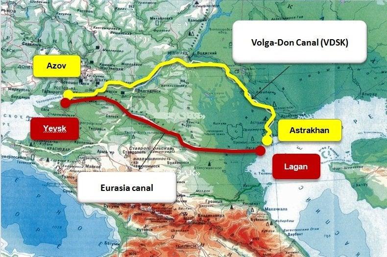
Figure 3 illustrates the projected route of the Eurasia Canal. The new canal will be much more feasible than the existing canal for several reasons. First of all, the canal is more direct, which means less transportation time and easy access to the open sea. Moreover, due to the relief of the terrain it will be easy to create a canal with a depth of around 7-8 meters and there are already existing reservoirs to fill it with water. And most importantly it requires fewer locks than the VDSC, which means less investment for construction. According to the Sinohydro Corporation’s research, the Eurasia Canal would be a vital feature for diverting Chinese freight transportation from the ocean to the territories of Russia and Kazakhstan to reduce transportation time. The research also highlights that the Eurasia Canal’s annual traffic would be 24–30 million tons by 2030 and 43–51 million tons by 2050 (Bekturganov and Bolaev, 2017).
Iranrud: The Trans-Iranian Canal
In 2012, during Ahmadinejad’s administration, Iran announced a megaproject called Iranrud (i.e. “Iran’s river”) to connect the Caspian Sea with the Persian Gulf or the Gulf of Oman. To do so, Iranian experts proposed two routes namely western and eastern routes, both of which have been approved by the government (Silavi 2020). Figure 4 illustrates the proposed paths to the Indian Ocean from the Caspian Sea. The western one starts from the southwest of the Caspian Sea to the far north of the Persian Gulf, the shortest possible route. The channel would start from Sefid Rud, the river that links with the Caspian, then continue to the Karun River and finally the Arvand River in the south, with a total length of around 950 km (Moazzen 2014). Those rivers are partially navigable and the initial plan was to connect them with artificial canals while simultaneously dredging them and making them suitable for navigation. However, this route is totally useless since it passes through a high mountain valley, the Albroz highland, with a length of about 600 km. To make a canal through mountains up to 1,800 meters high cannot be feasible at all. To do so dozens of locks would need to be constructed to lift and drop vessels. Therefore, experts have mainly focused on the second path — the Eastern route.
The Eastern route runs from southeast of the Caspian to the Gulf of Oman with a total length of 1,600 km. The area of the intended Trans–Iranian Canal encompasses desert areas such as Dasht-e Lut and Dasht-e Kavir, and according to Iranian experts, this route could simultaneously solve the water problem in those areas. The initial plan is to desalinate water from the Caspian Sea and pump out 500 million cubic meters of water annually to the canal to make it navigable from the Caspian to the high seas. However, for several reasons the project appears to be an opportunistic dream of the Iranian government.
Figure 4
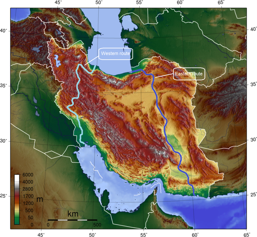
Both routes have specific hindrances that make the project unfeasible. The Western route would have to be constructed through a highland area, which is unrealistic. The Eastern route is too long to be feasible. Moreover, it is proposed to pump desalinated Caspian water into the canal. That would easily destroy the ecosystem of the region; hence no littoral country would let that happen. Even if we assume the minimum impact on the ecosystem, pumping out 500 million cubic meters of water annually will certainly have an impact on the level of the Caspian which would have catastrophic outcomes. Additionally, according to the World Meteorological Organization (WMO) the Dasht-e Lut salt desert where the canal is intended to be constructed holds the record for the hottest surface temperature on Earth, which can reach 70 degrees Celsius. How do the experts plan to handle the evaporation problem? All in all, I don’t see any prospects for this projected canal.
Conclusion
Being remote and landlocked is the main underlying factor behind higher transportation costs, less effectivity in terms of trade, and ultimately the slow pace of development in landlocked countries. The only way to overcome this curse is to construct a highly effective land-based corridor. Therefore, Azerbaijan, Kazakhstan, and Turkmenistan have invested heavily in infrastructure to create a seamless land–based transport corridor. However, no matter how effective your infrastructure capabilities are, they cannot be more effective than sea transportation. The above-mentioned countries have an advantage in that they are coastal countries of the Caspian water basin. Although it has several limitations, there is already a canal that links the Caspian with the open seas. Moreover, there is still hope that this canal can be enhanced or a new one can be constructed which is more effective and feasible, such as the Eurasia Canal. If the littoral countries, including Russia, collaborate jointly and achieve the construction of a practical and productive canal, the situation in the region would change significantly. The littoral countries would easily increase trade activities and eventually accelerate development.
Consider the following hypothetical example. Let us assume that an Azerbaijani businessman purchases CIF 20,000 metric tons (MT) of grain from Odesa, Ukraine to Baku each month. The buyer arranges a ship from Odesa to Poti and then 334 wagons (60 mt) from Poti to Baku. Moreover, he needs to pay for transit formalities such as custom, taxes, etc. at Odesa, Poti, and Baku. He also pays for storage at Poti or in Odesa, since it is not possible to ship 334 wagons in one go and he must send his cargo partially. We can assume that he will be able to find a vessel from Odesa to Poti for 14 USD per MT and from Odesa to Baku (Alat) for around 40 USD per MT for wagon transportation. In addition, around 13-15 USD per MT can be expected for other expenses as mentioned. In total, he will need to pay around 70 USD per metric ton for his shipment. On the other hand, let’s assume that there is an enhanced waterway system between the Caspian Sea and the Black sea that can accommodate a vessel with up to 10,000 mt of cargo. In this case, that businessman will need to pay around a maximum of 20-25 USD per metric ton from Odesa to Baku and fewer transit fees since he eliminated other expenses in Georgia. He will complete his shipment with just 2 sea voyages. That is why shipping is more effective and less time consuming than other modes of transportation.
The Volga–Don Canal today is not really effective due to its limitations. However, constructing a good canal such as Eurasia may make the above hypothetical example come true. In any case, I believe that the Caspian can be linked with the open seas in a more effective way and achieving that will completely change the development pace in landlocked countries of the Caspian region.
References:
1.UNCTAD (2017). Jan Hoffmann, H. B., Asariotis, R., & Assaf, M. (2017). UNCTAD Review of Maritime Transport.
2. UNCTAD (2019). Review of Maritime Transport 2019 (United Nations publication. Sales No. E.18.II.D.5. New York and Geneva.
3. Bekturganov, N. S., & Bolaev, A. V. (2017). The Eurasia Canal as a Factor of Economic Prosperity for the Caspian Region. Geography, Environment, Sustainability, 10(1), 34-43.
4. Limao, N., & Venables, A. J. (2001). Infrastructure, geographical disadvantage, transport costs, and trade. The world bank economic review, 15(3), 451-479.
5. Mukhtarov, A. The Trans-Caspian Corridor: the shortest path or a difficult bridge between East and West? https://bakuresearchinstitute.org/the-trans-caspian-corridor-the-shortest-path-or-a-difficult-bridge-between-east-and-west/
6. Peymãn Moazzen (2014) Iran rud: The Great Canal of Persia. Retrieved from: https://www.linkedin.com/pulse/20140929025021-63488664-iran-rud-the-great-canal-of-persia/
7. President Vladimir Putin has presented his Annual Address to the Federal Assembly (2007). Retrieved July 07, 2020, from http://en.kremlin.ru/events/president/transcripts/24203
8. Rom, V. Y. (1961). The Volga-Baltic Waterway. Soviet Geography, 2(9), 32-43.
9. Shaporenko, S. I., Van Geest, G. J., Minin, A. E., Middelkoop, H., Kuzovlev, V. V., Gorski, K., & Schletterer, M. (2019). The volga: management issues in the largest river basin in Europe.
10. Silavi, S. (2020, May 20). Doubts raised in Iran over environmentalist’s alleged ‘suicide’ death. Retrieved July 07, 2020, from https://english.alarabiya.net/en/features/2018/02/12/Doubts-raised-in-Iran-over-environmentalist-s-alleged-suicide-death
[1] The Volga–Baltic Waterway was initially constructed in 1811, however, the system was enhanced in the 1960s for larger vessels with drafts of up to 3 meters, becoming a part of the Unified Deep Water System of European Russia. Apart from Russia, the littoral countries barely use this canal.
Автор: А. Мухтаров (А. Mukhtarov)
Источник: https://bakuresearchinstitute.org/the-attempts-to-make-the-caspian-a-sea-and-the-reality/