В статье поднимаются чрезвычайно важные и актуальные проблемы морского права, причем фундаментальные. Так, рассматриваются определения понятий “море” и “озеро” и приложение их к конкретному объекту – Каспию. Исследуются также транспортные коридоры, связывающие Китай с Европейским Союзом, и влияние этих транспортных путей на экономику, в том числе на международную торговлю и экономику стран Каспийского бассейна. В заключение автор отмечает, что упрощение и облегчение транспортных процедур привлечет к этому транзитному региону повышенное внимание серьезных инвесторов.
he Caspian Sea is a water basin located in the heart of Central Asia, neighboring natural resource-rich countries. The existing geopolitical conditions and geographical obstructions make the problems of the Caspian region complicated to solve. First, being natural resource-rich has brought attention from Russia, the United States, the European Union, and many other big players in global industry and made the region very significant for others in terms of energy security. Second, although it is called a “sea,” the region is landlocked, which in turn is a troublemaker regarding the carriage of the freight to other destinations. Hence, there have been vast investments to build sufficient infrastructure to carry freight to and from the landlocked Caspian countries and create a smooth East–West transport corridor passing through the Caspian Sea region. Therefore, it can be easily said that prosperity is directly linked to accessibility in terms of the exchange of goods, information, and people. Accordingly, the question of how accessible the Caspian is for the global market needs to be analyzed. The first part of the article will briefly discuss the Caspian Sea itself, illustrating the arguments over whether it is a sea or a lake. The second part will discuss the existing condition of the transport corridor which starts from West China and connects to Europe bypassing from the Caspian Region.
A sea or a lake and why does it matter?
One of the main historical facts about the Caspian is that it can be traced back to the ancient Thetis Ocean, specifically its gulf which is named Parathetis. Roughly 50-60 million years ago, there were connections between the Thetis Ocean and the Atlantic along with the Pacific Oceans (Aladin and Plotnikov 2004). The movement of the continental shelves over time led to discontinuation of the flow between the present Caspian Basin and the ocean. Consequently, the Caspian Sea became the largest inland body of water on Earth, completely enclosed and containing brackish water. Being the trace of an ancient ocean is the source of its 12.5 g/kg (‰) salinity, which is higher than the Baltic Sea. Hence, although its geographical condition might have led to the water basin being called a lake, its brackish water, along with artificial channels which connect the Caspian with the world ocean, prevent it from being clearly categorized as a lake.
To overcome the issues which occur due to the lack of any natural linkage between the Caspian and the ocean, navigable channels (suitable for commercial shipping activities) have been constructed connecting the Baltic Sea, the Black Sea, and the Caspian. To be more specific, the Volga-Don canal connects the Caspian Sea to the Sea of Azov and subsequently to the Black Sea. On the other hand, the Volga-Baltic waterway systems connect the Caspian to the Baltic Sea. These are the arguments, among others, for calling the water basin a sea. The question is: why is it so important to define it as a sea or lake?
We need to clarify the usage of both terms. If the Caspian Sea is considered a large salty lake under the bordering countries’ jurisdictions, then the United Nations has no authority and international law cannot be applied over this region, hence the bordering countries may decide the fate of the so-called lake themselves. However, if the Caspian Sea is recognized as an enclosed sea, then the littoral countries must apply the United Nations Convention on the Law of the Sea, namely UNCLOS[1], to manage the status of the Caspian Sea (Zimnitskaya and Geldern 2011). Unfortunately, the Caspian Sea does not fit into any of those categories, neither sea nor lake by their literal meanings. Consequently, after the dissolution of the Soviet Union the littoral countries could not reach unanimity regarding the status of the Caspian. Therefore, this results in problems in the region in several areas, including the demarcation of borders, the commercial shipping industry, fishing zones, and even geopolitical conflicts among the littoral countries. Some conflicts have actually escalated from diplomatic disputes to the level where the military services have been involved (for example, an Azerbaijan–Iran conflict occurred on July 23, 2001, when Iranian warships and two military aircrafts threatened Azerbaijani survey vessels which were exploring an oil field on behalf of BP).
Although today the littoral countries have achieved partial agreement regarding the status of the Caspian, I believe that the Soviet–Iranian “closed sea” concept could be a handy tool to overcome the complexity for the beginning stage. According to international law, “closed sea” means a sea that has no natural linkage with the ocean and is surrounded by two or more states. Closed seas remain entirely under the exclusive control of the littoral states, which may exercise their sovereignty without any restriction either in the entire sea or its parts. Regretfully, not all the littoral countries consider the Caspian a “closed sea”; particularly, Azerbaijan and Kazakhstan claim that the Caspian should be called a lake.
Overcoming its landlocked condition
Calling the Caspian either a sea or a lake will only affect the laws that should be applied over the water basin to solve disputes among the littoral countries. However, its geographical obstructions i.e., the lack of any natural linkage to the world ocean, will always be there as a reminder that the region is landlocked. There are several channels that connect the Caspian with other seas, nevertheless, there are some fundamental problems with them. To be more precise, the Volga-Don and Volga-Balt canals have draft restrictions which affect the quantity of cargo that can be carried by ships. Moreover, during the winter season, those channels freeze interrupting navigation. Respectively, these facts demonstrate that the region is landlocked in any case. Therefore, the next part of the article will evaluate the disadvantages for trade stemming from the landlocked condition of the littoral countries along with the conditions of the transport corridors that pass through the Caspian Sea.
Having direct linkage to the seas offers noteworthy benefits for coastal countries in terms of less borders and associated limitations. The situation in terms of trade and freight carriage for landlocked countries, however, is a sharp contrast. Seas and ocean transportation are key underlying factors lowering transportation costs due to extensive usage of economies of scale by seagoing vessels. On the contrary, without direct access to the open seas, international trade opportunities and freight carriage are limited by modes of transportations which have less ability to use economies of scale in order to decrease the cost of transportation for one unit. Weak connectivity can damage the economic conditions of landlocked developing economies, especially distressing their small and medium-sized enterprises (Arvis et al. 2011). Limão and Venables (2001) showed that a 10% decrease in transport costs increases trade by 25%. Moreover, the authors added that landlocked economies’ transport costs are approximately 50% higher compared to coastal economies.
Consequently, regional corridors are critical for landlocked countries, which suffer from serious trade and accessibility issues. In particular, if the region is rich in natural resources, such as Kazakhstan, Turkmenistan, and Azerbaijan, which are littoral countries of the Caspian Sea, then an efficient transportation system becomes one of the major conditions of prosperity. Those named countries are three out of 32 landlocked developing countries in the world which are located near an enclosed water basin, e.g. the Caspian Sea. Additionally, being situated in the middle of an East-West transport corridor is a source of promising opportunities for providing alternative routes for projects, such as the Belt and Road Initiative (BRI). The main goal of the BRI is to provide an alternative to the established transport lines by constructing new connections between Europe and Asia. The project is based on Eurasian railway networks and road connections that are planned to be developed on the historic Silk Roads.
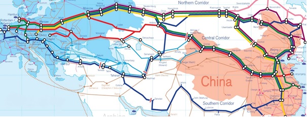
What are transport corridors and why is their efficiency the key to prosperity? Transport corridors mostly involve infrastructure capabilities that provide physical links to an area in any given country or to a region which previously lacked that connection (Nogales 2014). Infrastructure capability encompasses multimodal transport corridors that produce numerous connections by integrating several types of transport modes, such as road, rail, inland waterways, and short sea shipping. Besides, a logistics corridor is an advanced stage of corridor development, in which already existing physical links in a given region are also accompanied by the harmonization of the institutional framework (Banomyong 2008). The dominant goal of a logistic corridor is to enhance the flow and storage of goods, people, and related information. This includes improving logistics and all related technological, organizational, and legal conditions, which is achieved with the support of service providers and a facilitating institutional environment. There are a considerable number of rail and road corridors within Eurasia that have been classified by different international organizations (Ziyadov 2011). Due to geographical and political factors, the Eurasian transport corridors have been segmented into three categories; Northern Routes, Central (TRACECA) Routes and Southern Routes.
The map in Figure 1 illustrates each transport corridor connecting Asia and Europe. However, due to the scope of the research, only TRACECA, specifically its Trans Caspian logistics corridor, will be discussed to indicate the pros and cons of the projected route.
Figure 1: Eurasian transport corridors
Central Corridor: A logistics bridge between China, the Caspian, and Europe
As previously stated, a transport corridor is the backbone of development for landlocked countries. TRACECA is a such program intended to connect China and the Commonwealth of Independent States to Europe through the Caucasus and/or the Black Sea. According to Ozyanik (2015), “the key objective of the TRACECA Program is to harmonize customs and trade regulations among the member states, to facilitate trade and movement of goods, and to ensure the integration of the resource-rich regional countries with global markets.” The TRACECA transport program includes 22 land-based connections (4 by rail, 6 by road and 12 by rail and road) and 12 ports (Keser 2015).
Transport corridors such as TRACECA cross several countries’ borders and customs controls, frequently resulting in delays and poor logistical performance due to low integration levels. The creation of logistics corridors has been shown to enhance the capability of the corridors described above. To overcome such problems, the Trans-Caspian International Transport Route (TITR) logistics corridor has been established as an extension of the TRACECA program. The railway and port authorities of Azerbaijan, Kazakhstan, and Georgia signed an agreement on developing the Trans-Caspian International Transport Route Association in 2016 (Nazarli 2017). Moreover, by 2017, the International Association of the TITR signed a memorandum of cooperation with the China Communications and Transportation Association in a meeting attended by 80 representatives of railway departments, port, shipping, and logistics companies from Kazakhstan, China, Ukraine, Poland, Turkey, Azerbaijan, Georgia, Lithuania, and Latvia (Israfilbayova 2017).
Figure 2: Alternative routes from China to Europe
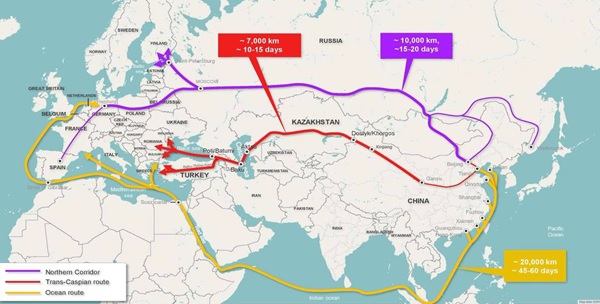
As can be seen from figure 2, using maritime transportation is almost three times more time-consuming in comparison to the abovementioned logistics corridor. For example, a vessel which is loaded in Shanghai, Shenzhen, or Qingdao requires a minimum of 40-45 days to reach a port of discharge located in Europe. Meanwhile, if the freight is transferred via the TITR, that transportation duration will be reduced to just 13 or 15 days. The newly added Baku-Tbilisi-Kars leg of the corridor, i.e. the BTK railway project, which has a price tag of $1 billion, was initiated in 2005 and construction started in 2007. The line will mainly be used to transport 1 million passengers and 6.5 million tons of freight a year. In the long run, its capacity is projected to reach up to 17 million tons annually.
Hence, it is easy to claim that the route, along with its freshly added infrastructure capabilities, will lead to a tremendous upsurge in the trade volume between Europe and Asia and, in turn, goods will be delivered to end-users in a shorter period. Since the duration of transport will be three times shorter with the TITR, the risks that are encountered during the long sea voyage, such as deviation due to weather conditions, loss of cargo, etc. will be lessened or even eliminated. All in all, reducing transportation time, along with the abovementioned advantages, will result in surplus in stock capability and flexibility to meet recent trends, which are critical for intermediate supply chain users and ultimately will favorably affect the cost of goods.
How efficient is that logistics corridor and is it really likely to provide prosperity for its coverage area? To elaborate the real potential of the TITR as a logistics corridor, the efficiency of several means of transportation and transportation duration should be analyzed. A study was conducted, the main goal of which was to examine the factors that can be highlighted as barriers and bottlenecks for the logistics procedure on the selected route. According to Sladkowski and Ciesla (2015), time and cost factors are the fundamental factors that need to be taken into account when making optimal decisions regarding the carriage of freight by forwarders. Since the TITR as a transport corridor involves several countries, it will definitely face several challenges to become a smoothly operating corridor. A review of the related literature shows that barriers to the development of the transport corridor are categorized as Physical Barriers and Non-Physical Barriers.
Physical Barriers: These obstacles include technical capabilities that prevail over the entire corridor and affect the feasibility of the whole route. That technical structure is the biggest underlying bottleneck which disrupts the integration level within the trans-Caspian route. The technical barriers can be classified as follows: scarce infrastructure, capacity limitation, and multimodality.
Scarce infrastructure: Although there has been a huge amount of investments in the infrastructure capacity, the corridor still lacks a sufficient level of technical capability. There are two main sources of this insufficiency: different gauge systems and low average speed. As is well-known, the former Soviet countries have different railway gauge systems than Europe and China. The Soviet-based railway system was created on broad gauge rails where the width of the gauge is 1520 mm. In contrast, China and Europe use the standard gauge system in which the width is 1435 mm. Hence, it requires alteration on the railway system along the corridor. In addition, the average speed of the route is estimated at 40 km/h, which is significantly less than advanced railway systems.
Capacity Limitation: There are three identified causes limiting the capacity of the trans-Caspian corridor: the number of wagons in use, double-stack restriction, and sea passage limitation due to permissible draft at Caspian ports. Although the exact number of wagons in use in the logistics corridor is unknown, there have been numerous complaints from shippers struggling to find suitable wagons to carry their cargos. That problem occurs on the sea leg of the passage resulting in discharging process delays due to the wait time for wagons. Moreover, most of the land-based carriers prefer to have double–stack container carriers, whereby two containers can be carried on top of one railway platform. However, according to Nazarko et al. (2016), only half of the route meets double-stack standards, and major parts of it remain non-electrified. And lastly, capacity problems occur during sea passage as well. Namely, there are factors that affect the quantity that can be shipped on vessels: firstly, vessels’ capacity and, secondly, port capacity. Port capacity is directly linked to draft restrictions across the region. Since the deepest port draft can reach around 5 meters (for dry cargo piers) within the Caspian Sea, a vessel can be loaded till its draft reaches that number. Hence, purchasing a big vessel to carry more cargo in one transportation unit will not be technically possible. Consequently, it requires again a vast investment to dredge the ports.
Multimodality: Multimodal transportation is where freight is shipped to its end user using several types of transport units. When we look at the trans-Caspian route, it will indeed require at least two transport units in order to make a shipment; one of them is railway or motorway, and the second is ship passage. Changing the unit means time loss, and the risks that occur due to several loading and unloading processes. Imagine, cargo sent from China by railway passes through Kazakhstan and reaches the port of Aktau (Kazakhstan). Then the cargo needs to be loaded onto a vessel and again discharged at Baku to continue its voyage.
Non-Physical Barriers: These include soft infrastructure matters, such as facilitation policies, border controls, and tariffs. Facilitation means, for example, a system whereby a shipper may perform all the necessary actions and provide relevant docs without knocking door by door at each country’s border and customs entities. E-cargo document systems are real examples that show how electronic documentation systems may facilitate and speed up the whole process. One–window customs services can be shown as an example of facilitation action as well. Nevertheless, none of the abovementioned services are in use along the corridor which in turns affects the whole transportation process and prevents more shippers from using this route. The TITR contains several border crossings and customs clearance checkpoints which respectively lead to serious dependency in terms of timing along the logistics corridor.
Conclusion
The first section of the article illustrated the present condition of the Caspian Sea, in terms of the complexity which occurs due to either geopolitical reasons or geographical obstructions. Lacking unanimity regarding its status, which can be considered a fundamental aspect to the solution of several issues, prevents the use of the sea to its full potential. The absence of demarcation of the sea between the neighboring countries and the incomplete agreement regarding common use of the water basin lead to some instabilities which discourage interest from global players as well.
Furthermore, it can be easily said that nowadays economic improvement is strictly correlated with the level of the integration with the global market, and coastal countries have specific advantages in terms of their access to global trade with cheaper transportation services. Landlocked countries, meanwhile, do not enjoy favorable conditions in this respect. Lacking direct linkage to the world ocean, landlocked countries can be seen as unreliable partners due to expensive trade procedures.
Lastly, although the region is resource-rich but landlocked, its other advantage is to be situated at the center of China–EU land-based transport corridors. The advantage of these transport corridors demonstrates that, if the procedures were facilitated and improved, it would attract more interest than it ever has before. The investments of China, the EU, and regional countries illustrate that all the countries involved see significant opportunities in the future based on these transport corridors. In particular, the Trans-Caspian International Transportation Route is a hidden treasure if these issues are solved. It could easily lead to a high level of containerization perspectives on the Trans-Caspian route. Specifically, within 3-5-years, container transportation volume on the TITR is very likely to achieve 50,000–100,000 TEU annually.
References
Aladin, N., & Plotnikov, I. (2004). The Caspian Sea. Lake Basin Management Initiative Thematic Paper.
Arvis, J. F., Smith, G., & Carruthers, R. (2011). Connecting landlocked developing countries to markets: Trade corridors in the 21st century. The World Bank.
Banomyong, R. (2008). Logistics development in the north-south economic corridor of the greater mekong subregion. Journal of GMS Development Studies, 4, 43-58.
Gálvez Nogales, E. (2014). Making economic corridors work for the agricultural sector. FAO.
Keser, H. Y. (2015). Importance of Transport Corridors in Regional Development: The Case of TRACECA. Sosyoekonomi, 23(24), 163-182.
Limao, N., & Venables, A. J. (2001). Infrastructure, geographical disadvantage, transport costs, and trade. The World Bank Economic Review, 15(3), 451-479.
Nazarko, J., Kuźmicz, K. A., & Czerewacz-Filipowicz, K. (2016). The New Silk Road–Analysis of the potential of new Eurasian transport corridors.
Nazarlı, A. (2017) “Tariffs for Trans-Caspian transport route to be agreed soon”, Pressreader, 5 April.
Ozyanik, S. (2015). TRACECA: Restoration of Silk Road. Journal of Caspian Studies, 1(2), 1-12.
Sladkowski, A., & Ciesla, M. (2015). Influence of a potential railway line connecting the Caspian Sea with the Black Sea on the development of Eurasian trade. NAŠE MORE: znanstveno-stručni časopis za more i pomorstvo, 62(4), 264-271.
Zimnitskaya, H., & Von Geldern, J. (2011). Is the Caspian Sea a sea; and why does it matter? Journal of Eurasian studies, 2(1), 1-14.Israfilbayova, S. (2017). SOCAR President reveals Shah Deniz gas output. Azernews. September, 20.
Ziyadov, T. (2011). Azerbaijan as a regional hub in Central Eurasia. Strategic Assessment of Euro-Asian Trade and Transportation. Caspian Strategy Institute. Retrieved from: https://search.wikileaks.org/gifiles/attach/37/37202_Azerbaijan%20as%20a%20Regional%20Hub%20in%20Central%20Eurasia_TZiyadov_new.pdf
[1] UNCLOS defines the rights and responsibilities of nations with respect to their use of the world’s oceans. It establishes guidelines for businesses, the environment and the management of marine natural resources.